-
 Share on social media
 -
 Copy URL
 -
 Mail to

Wednesday, June 21 2023
Introduction
Navigation is a key part of maritime safety, both to avoid obstacles and reach one’s destination without running out of resources. Consequently, the position of navigator onboard a vessel has always been highly skilled and valuable. What tools a navigator would use, however, has changed much over the course of history. Charting the evolution of navigation tools and techniques allows one to appreciate the true difficulty and importance of wayfinding at sea.
Ancient Techniques
Even in ancient times, people knew how to plot their course. The most basic technique, available to all, was following the coastline and looking for landmarks. Maps and charts could be used, but they were only as good as their creators. A more complex method, known as ‘dead reckoning’, allowed a navigator to calculate their course based on the vessel’s speed, direction of travel as determined by the sun, and the passage of time. However, without the tools to properly measure these factors, it was inaccurate, nor did it account for drift due to currents or wind.
In clear weather, the sky provided one of the most reliable ancient navigation methods. The Phoenicians- a Mediterranean trading civilisation- used the stars, such as the Pole Star and some constellations, depending on time of year. The Polynesians were arguably the masters of ancient navigation, using the stars, feeling the flow of currents, observing seabirds, and even cloud formation to find new islands. Given this, it is hardly surprising they colonised the entire Pacific Ocean.
Tools of the Trade
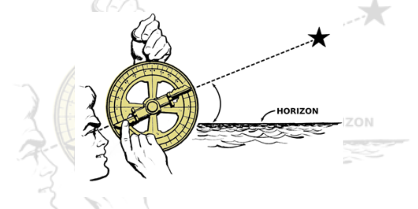
However, most navigators still found their art to be less than perfect. To improve precision, a variety of tools were created or adapted from other disciplines. For example, the mariner’s astrolabe was a tool adopted around 1470 by the Portuguese from Islamic astronomers to calculate time and position using the angle between the horizon and the sun or a star. 1
Like all celestial navigation, the astrolabe was limited by reliance on clear weather. The first major break away from needing to see the sun or stars was the adoption of the compass as a maritime navigational tool. Brought from China to Europe in the 12th century, the compass made it possible to sail even in overcast weather. 2 They were often decorated with a compass rose, showing the cardinal directions. Another tool developed was a sounder: a lead weight dropped from a long line, which could tell the navigator the depth of the water if they were close to shore.
Nevertheless, celestial navigation remained popular. Other tools, such as quadrants and cross-staves were created to help measure the angle of the sun or any other celestial body. They were often much simpler to use than an astrolabe and thus more accessible to an ordinary sailor.
Using an astrolabe at sea
Using an astrolabe at sea
Using an astrolabe at sea
Using an astrolabe at sea
Drawing after Edmund Gunter, 1624
Drawing after Edmund Gunter, 1624 ©Wellcome Collection
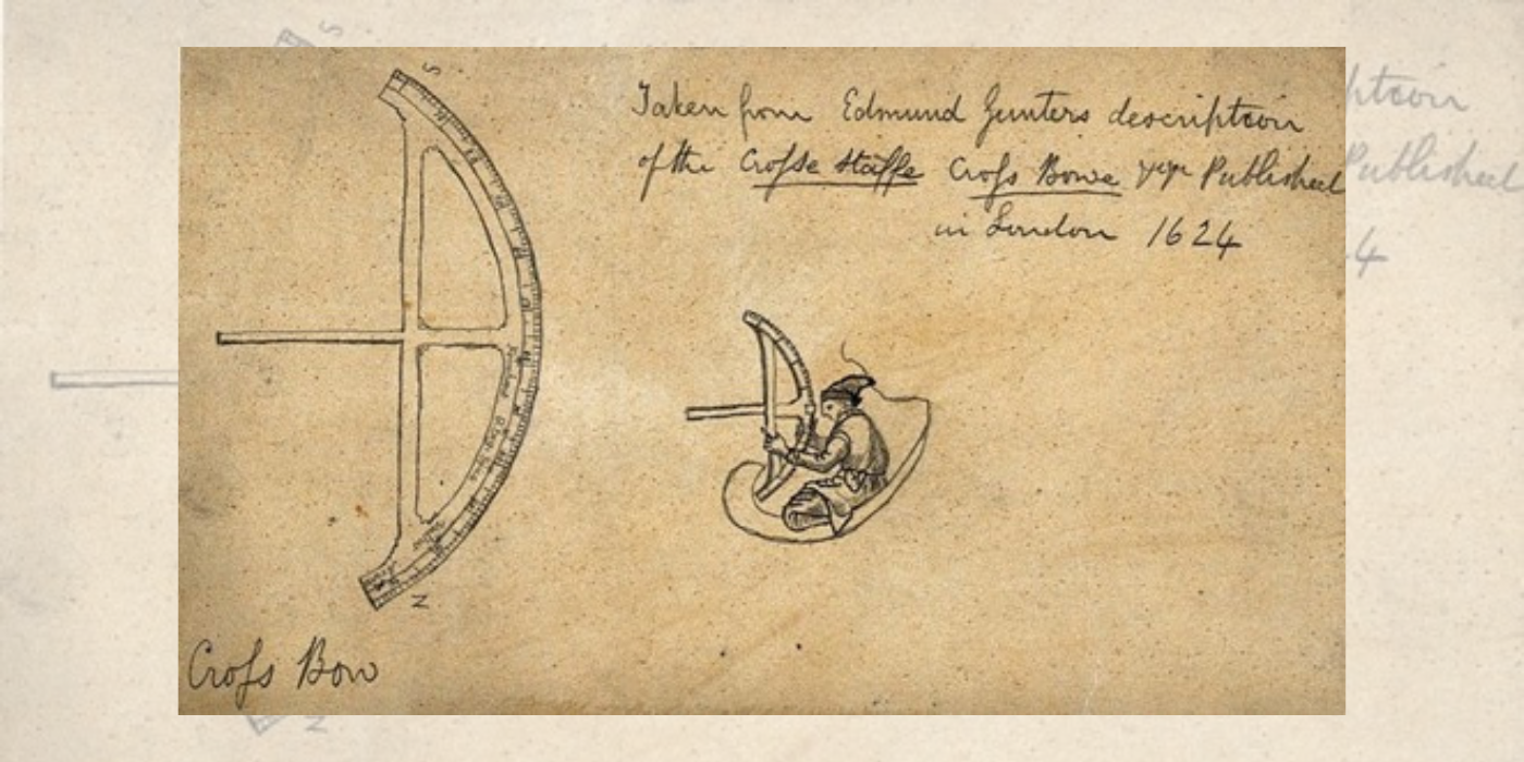
A cross-staff or cross-bow, and a sailor using the device. Drawing after Edmund Gunter, 1624.
Drawing after Edmund Gunter, 1624 ©Wellcome Collection
Using an astrolabe at sea
Using an astrolabe at sea
Using an astrolabe at sea
Using an astrolabe at sea
Drawing after Edmund Gunter, 1624
Drawing after Edmund Gunter, 1624 ©Wellcome Collection
A cross-staff or cross-bow, and a sailor using the device. Drawing after Edmund Gunter, 1624.
Drawing after Edmund Gunter, 1624 ©Wellcome Collection
The Longitude Problem
All of these tools were good at telling a ship its latitude, but longitude was much trickier. The major challenge here was being unable to accurately tell time. This was such a huge issue that in 1714, Parliament passed the Longitude Act, which would provide a prize of up to £20,000 (£3.15 million today) to anybody who could find a method to determine longitude to within 30 miles. 3
One method created to tell longitude was lunar distance: measuring the space between the moon and another celestial body, and using that to calculate time at the newly established Greenwich Meridian. This was aided by several new inventions in the mid-18th century that used mirrors to measure distances of objects in the sky: first the octant, capable of measuring up to 90 degrees, then the sextant, which could measure up to 120 degrees. 4 Both, like the astrolabe before them, were based on Arabic astronomical instruments.
A more reliable method dawned with the creation of an accurate chronometer by carpenter John Harrison between 1735 and 1765. One of his chronometers, H4, was accurate to within 6 seconds, and H5 was accurate to 0.2 seconds. 5
Mariners could now tell longitude by comparing their measurements to Greenwich Meridian time and seeing how far off their local time was. From 1884, the Greenwich Meridian was considered standard across the world. 6 The longitude problem was solved.
Marine Timekeeper
Marine Timekeeper ©L2015-3480, Science Museum Group
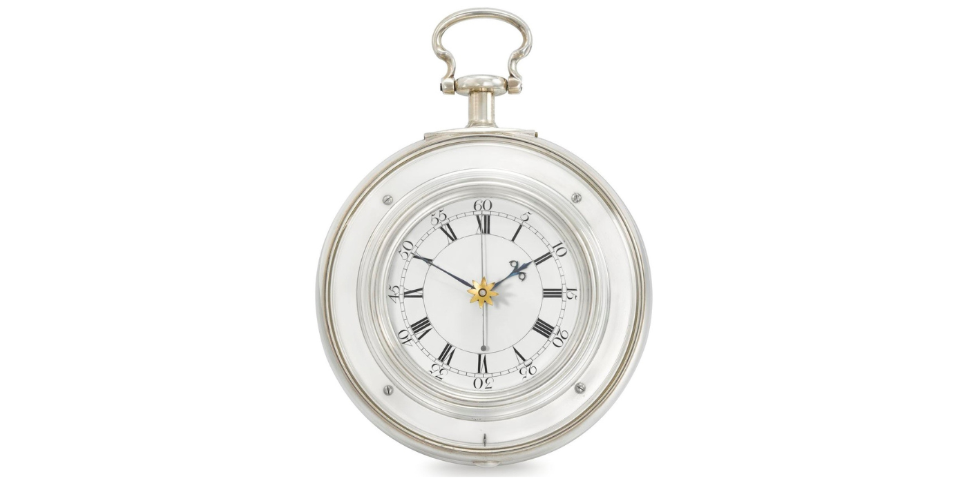
Marine Timekeeper known as 'H5' by John Harrison and Son 1770.
Marine Timekeeper ©L2015-3480, Science Museum Group
AIS display of the English Channel
AIS display of the English Channel
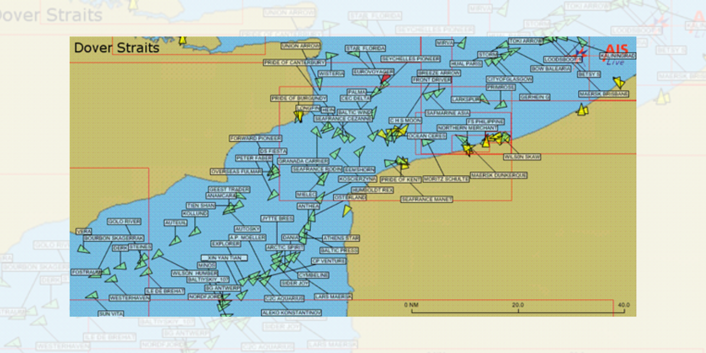
AIS display of the English Channel, showing real time maritime traffic
AIS display of the English Channel
Marine Timekeeper
Marine Timekeeper ©L2015-3480, Science Museum Group
Marine Timekeeper known as 'H5' by John Harrison and Son 1770.
Marine Timekeeper ©L2015-3480, Science Museum Group
AIS display of the English Channel
AIS display of the English Channel
AIS display of the English Channel, showing real time maritime traffic
AIS display of the English Channel
Radio and Radar
The art of navigation remained largely unchanged until the beginning of the 20th century, when a pair of Italian officers developed an instrument which could determine the location of a radio transmitter. Such transmitters were soon built on coastlines all over the world, while ships began to be fitted with these radio receivers. They could now get accurate information on time or obstacles. It could also be used in any weather at any time of day.
During and after the Second World War, navigation continued to innovate. A notable invention was radar, which came into use on military ships in 1943 and then a civilian vessel in 1947. 7 Radar allowed for instant access to information about obstacles, allowing navigators to plot and adjust their courses in real time. Sonar, introduced in the 1920s, enabled them to create images of the sea floor in a similar way: a far cry from the lead sounder used in the Middle Ages.
A major milestone came in 1944, when the US set up a series of long-range navigation stations known as LORAN (short for Long Range Navigation). These enabled a ship to measure radio pulses sent by paired radio stations over distances as far as 1,500 miles. In modern times, however, technology marches on at an incredible rate. It was not long before LORAN was replaced.
Satellite Takes Off
Today, most ships are fitted with GPS and AIS transmitters and receivers, and all over a certain size require it under SOLAS (Safety of Life at Sea) regulations. The first of the GPS (Global Positioning System) network of satellites was first launched in 1978, and the whole thing became operational in 1993. 8 They broadcast signals to ships in real time, allowing the vessel to know where it is instantly. The same data is channelled to the Automatic Identification System or AIS which maps the locations of all vessels in real time. Not only can a ship now see where it is, but it can see where everyone else is, helping avoid collisions and sticking to established shipping lanes.
In a way, navigation has come full circle: mariners once again depend on the heavens to guide them. Instead of fixed stars, however, they look to tiny orbiting man-made specks whose signals are read not by charts and sextants, but by a computer. It is dizzying to imagine where we can go from such heights.
Footnote hovee text
-
Share on social media
-
Copy URL
-
Mail to
Footnotes
-
1
“What Is a Mariner’s Astrolabe?” Royal Museums Greenwich, <www.rmg.co.uk/stories/topics/what-mariners-astrolabe> Accessed 21 May 2023.
-
2
Lane, Frederic C. “The Economic Meaning of the Invention of the Compass.” The American Historical Review, vol. 68, no. 3, 1963, pp. 605–17
-
3
Spencer, Robin W. “Open Innovation in the Eighteenth Century: The Longitude Problem.” Research Technology Management, vol. 55, no. 4, 2012, pp. 39–43.
-
4
“Sextant with Beveled Scale.” The Institute of Navigation’s Navigation Museum, www.ion.org/museum/item_view.cfm?cid=2&scid=14&iid=29. Accessed 21 May 2023.
-
5
Rosenkrantz, Kurt. “Celestial Navigation.” Science Scope, vol. 29, no. 1, 2005, pp. 30–36
-
6
“The Adoption of a Prime Meridian and the International Meridian Conference of 1884.” The Greenwich Meridian, www.thegreenwichmeridian.org/tgm/articles.php?article=10. Accessed 21 May 2023.
-
7
Ilcev, D. S. “The development of maritime radar. Part 2: Since 1939”, International Journal of Maritime History, 32(4), 2020, pp. 1008–1022
-
8
“Global Positioning System History.” Edited by Thuy Mai, NASA, 27 Oct. 2012, www.nasa.gov/directorates/heo/scan/communications/policy/GPS_History.html.
More stories